
Daggett County topographic map
Interactive map
Click on the map to display elevation.
About this map
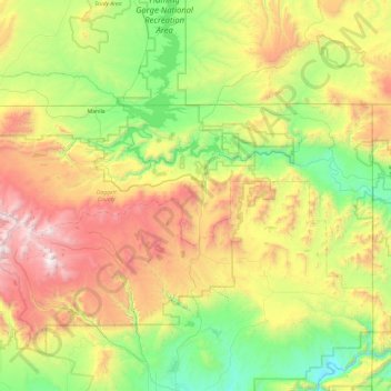
Name: Daggett County topographic map, elevation, terrain.
Location: Daggett County, Utah, 84023, United States of America (40.65360 -110.00073 41.00069 -109.04846)
Average elevation: 2,267 m
Minimum elevation: 1,508 m
Maximum elevation: 3,735 m
Other topographic maps
Click on a map to view its topography, its elevation and its terrain.
Utah County
United States of America > Utah
Utah County, Utah, United States of America
Average elevation: 2,062 m
Box Elder County
United States of America > Utah
Box Elder County, Utah, United States of America
Average elevation: 1,519 m
Ephraim
United States of America > Utah > Ephraim
Ephraim, Utah, 84627, United States of America
Average elevation: 1,700 m
Levan
United States of America > Utah > Levan
Levan, Utah, United States of America
Average elevation: 1,624 m
Pioneer Stadium
United States of America > Utah > Ogden
Pioneer Stadium, Ogden, Weber County, Utah, United States of America
Average elevation: 1,327 m
Tooele County
United States of America > Utah
Tooele County, Utah, United States of America
Average elevation: 1,462 m
Fielding
United States of America > Utah > Fielding > Fielding
Fielding, Box Elder County, Utah, 84311, United States of America
Average elevation: 1,329 m
Duchesne County
United States of America > Utah
Duchesne County, Utah, United States of America
Average elevation: 2,408 m