
Bachte-Maria-Leerne topographic map
Interactive map
Click on the map to display elevation.
About this map
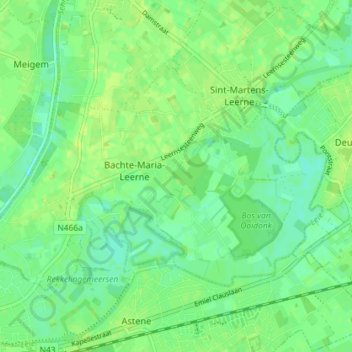
Name: Bachte-Maria-Leerne topographic map, elevation, terrain.
Location: Bachte-Maria-Leerne, Deinze, Gent, Oost-Vlaanderen, België (50.98851 3.52993 51.01768 3.60166)
Average elevation: 8 m
Minimum elevation: 1 m
Maximum elevation: 13 m
Other topographic maps
Click on a map to view its topography, its elevation and its terrain.
De Soeverein
België > Oost-Vlaanderen > Gent > Deinze > Petegem-aan-de-Leie
De Soeverein, Petegem-aan-de-Leie, Deinze, Gent, Oost-Vlaanderen, Vlaanderen, 9800, België
Average elevation: 10 m
Landegem
België > Oost-Vlaanderen > Gent > Deinze
Landegem, Deinze, Gent, Oost-Vlaanderen, 9850, België
Average elevation: 8 m
Merendree
België > Oost-Vlaanderen > Gent > Deinze
Merendree, Deinze, Gent, Oost-Vlaanderen, België
Average elevation: 6 m
Nevele
België > Oost-Vlaanderen > Gent > Deinze
Nevele, Deinze, Gent, Oost-Vlaanderen, België
Average elevation: 8 m
Astene
België > Oost-Vlaanderen > Gent > Deinze
Astene, Deinze, Gent, Oost-Vlaanderen, België
Average elevation: 9 m
Petegem-aan-de-Leie
België > Oost-Vlaanderen > Gent > Deinze
Petegem-aan-de-Leie, Deinze, Gent, Oost-Vlaanderen, Vlaanderen, 9800, België
Average elevation: 10 m
Grammene
België > Oost-Vlaanderen > Gent > Deinze
Grammene, Deinze, Gent, Oost-Vlaanderen, België
Average elevation: 9 m
Gottem
België > Oost-Vlaanderen > Gent > Deinze
Gottem, Deinze, Gent, Oost-Vlaanderen, België
Average elevation: 9 m
Hansbeke
België > Oost-Vlaanderen > Gent > Deinze
Hansbeke, Deinze, Gent, Oost-Vlaanderen, Vlaanderen, België
Average elevation: 7 m
Zeveren
België > Oost-Vlaanderen > Gent > Deinze
Zeveren, Deinze, Gent, Oost-Vlaanderen, België
Average elevation: 10 m
Poesele
België > Oost-Vlaanderen > Gent > Deinze
Poesele, Deinze, Gent, Oost-Vlaanderen, België
Average elevation: 9 m
Vosselare
België > Oost-Vlaanderen > Gent > Deinze
Vosselare, Deinze, Gent, Oost-Vlaanderen, Vlaanderen, België
Average elevation: 9 m
Sint-Martens-Leerne
België > Oost-Vlaanderen > Gent > Deinze
Sint-Martens-Leerne, Deinze, Gent, Oost-Vlaanderen, Vlaanderen, België
Average elevation: 9 m
Wontergem
België > Oost-Vlaanderen > Gent > Deinze
Wontergem, Deinze, Gent, Oost-Vlaanderen, België
Average elevation: 12 m