
Kumtich topographic map
Interactive map
Click on the map to display elevation.
About this map
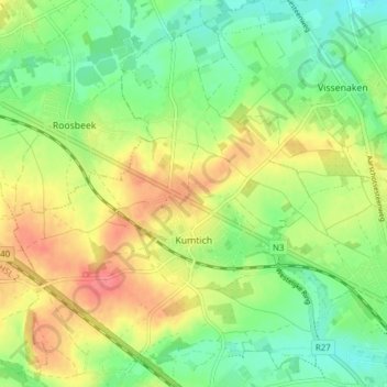
Name: Kumtich topographic map, elevation, terrain.
Location: Kumtich, Tienen, Leuven, Vlaams-Brabant, Vlaanderen, België (50.80034 4.85161 50.84890 4.91405)
Average elevation: 64 m
Minimum elevation: 36 m
Maximum elevation: 98 m
Other topographic maps
Click on a map to view its topography, its elevation and its terrain.
Tienen
België > Vlaams-Brabant > Leuven > Tienen
Tienen, Leuven, Vlaams-Brabant, Vlaanderen, 3300, België
Average elevation: 54 m
Sint-Pieter
België > Vlaams-Brabant > Leuven > Tienen > Vissenaken
Sint-Pieter, Vissenaken, Tienen, Leuven, Vlaams-Brabant, Vlaanderen, 3300, België
Average elevation: 59 m
Goetsenhoven
België > Vlaams-Brabant > Leuven > Tienen
Goetsenhoven, Tienen, Leuven, Vlaams-Brabant, Vlaanderen, België
Average elevation: 72 m
Hakendover
België > Vlaams-Brabant > Leuven > Tienen
Hakendover, Tienen, Leuven, Vlaams-Brabant, Vlaanderen, België
Average elevation: 49 m
Vissenaken
België > Vlaams-Brabant > Leuven > Tienen
Vissenaken, Tienen, Leuven, Vlaams-Brabant, Vlaanderen, België
Average elevation: 56 m
Oplinter
België > Vlaams-Brabant > Leuven > Tienen
Oplinter, Tienen, Leuven, Vlaams-Brabant, Vlaanderen, België
Average elevation: 45 m
Sint-Margriete-Houtem
België > Vlaams-Brabant > Leuven > Tienen
Sint-Margriete-Houtem, Tienen, Leuven, Vlaams-Brabant, Vlaanderen, België
Average elevation: 57 m
Grimde
België > Vlaams-Brabant > Leuven > Tienen
Grimde, Tienen, Leuven, Vlaams-Brabant, 3300, België
Average elevation: 51 m