
Thank you for supporting this site ❤️
Make a donation
Make a donation
Cabeza de Vaca topographic map
Click on the map to display elevation.
Thank you for supporting this site ❤️
Make a donation
Make a donation
About this map
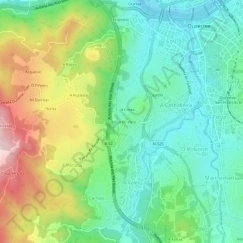
Name: Cabeza de Vaca topographic map, elevation, terrain.
Location: Cabeza de Vaca, Ourense, Orense, Galicia, 32002, España (42.30784 -7.90458 42.34784 -7.86458)
Average elevation: 224 m
Minimum elevation: 91 m
Maximum elevation: 490 m
Thank you for supporting this site ❤️
Make a donation
Make a donation
Other topographic maps
Click on a map to view its topography, its elevation and its terrain.