
Feilding topographic map
Click on the map to display elevation.
About this map
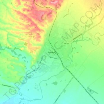
Name: Feilding topographic map, elevation, terrain.
Average elevation: 84 m
Minimum elevation: 41 m
Maximum elevation: 158 m
Manawatū District trails, hiking, mountain biking, running and outdoor activities
Other topographic maps
Click on a map to view its topography, its elevation and its terrain.
Kitchener Park
New Zealand > Manawatu-Whanganui > Manawatū District > Feilding
Average elevation: 63 m