
Make a donation
New Cumberland topographic map
Click on the map to display elevation.
Make a donation
About this map
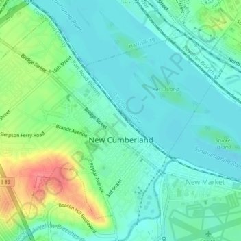
Name: New Cumberland topographic map, elevation, terrain.
Average elevation: 113 m
Minimum elevation: 87 m
Maximum elevation: 154 m
Make a donation
Other topographic maps
Click on a map to view its topography, its elevation and its terrain.
Carlisle Springs
United States > Pennsylvania > Cumberland County > Middlesex Township
Average elevation: 182 m
Mount Zion
United States > Pennsylvania > Cumberland County > South Middleton Township
Average elevation: 179 m
Chestnut Crossroads
United States > Pennsylvania > Cumberland County > Southampton Township
Average elevation: 256 m
Pine Grove Furnace
United States > Pennsylvania > Cumberland County > Cooke Township
Average elevation: 332 m
Make a donation
Carlisle Springs
United States > Pennsylvania > Cumberland County > Middlesex Township
Average elevation: 182 m
Treemont
United States > Pennsylvania > Cumberland County > East Pennsboro Township
Average elevation: 162 m
Green Spring
United States > Pennsylvania > Cumberland County > North Newton Township
Average elevation: 174 m
Caprivi
United States > Pennsylvania > Cumberland County > North Middleton Township
Average elevation: 156 m
Make a donation
Springville
United States > Pennsylvania > Cumberland County > South Middleton Township
Average elevation: 162 m
Liebys Trailer Park
United States > Pennsylvania > Cumberland County > Liebys Trailer Park
Average elevation: 138 m
Drexel Hills
United States > Pennsylvania > Cumberland County > New Cumberland
Average elevation: 111 m