
Neumarkt in der Oberpfalz topographic map
Interactive map
Click on the map to display elevation.
Neumarkt in der Oberpfalz
Neumarkt lies on the western edge of the Franconian Jura, nestled in a valley. The municipal region reaches as far as the Bavarian Jura to the east. The Neumarkt valley drains to the north through the Schwarzach River, a tributary of the Regnitz, eventually flowing into the Main, and to the south through the Sulz, a tributary of the Altmühl, which eventually flows into the Danube. The Ludwig Canal cuts through the area from North to South, bridging the European water divide. The elevation varies from 406 meters on the Beckenmühle River to the north, to 595 meters in the vicinity of Fuchsberg; as a reference, the elevation of city hall is given as 423 meters.
About this map
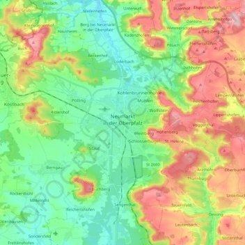
Name: Neumarkt in der Oberpfalz topographic map, elevation, terrain.
Average elevation: 479 m
Minimum elevation: 398 m
Maximum elevation: 618 m