
Zielona Góra topographic map
Interactive map
Click on the map to display elevation.
About this map
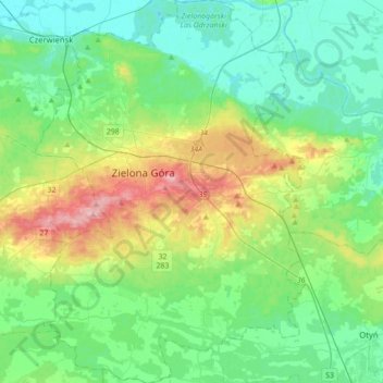
Name: Zielona Góra topographic map, elevation, terrain.
Location: Zielona Góra, Nowa Sól County, Lubusz Voivodeship, Poland (51.82017 15.39075 52.03511 15.65243)
Average elevation: 87 m
Minimum elevation: 42 m
Maximum elevation: 214 m
Other topographic maps
Click on a map to view its topography, its elevation and its terrain.
Krosno Odrzańskie
Poland > Lubusz Voivodeship > Krosno Odrzańskie
Krosno Odrzańskie, gmina Krosno Odrzańskie, powiat krośnieński, Lubusz Voivodeship, Poland
Average elevation: 54 m