
Thank you for supporting this site ❤️
Make a donation
Make a donation
Los Rodriguez topographic map
Click on the map to display elevation.
Thank you for supporting this site ❤️
Make a donation
Make a donation
About this map
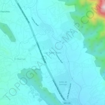
Name: Los Rodriguez topographic map, elevation, terrain.
Location: Los Rodriguez, Santiago, Nuevo León, 67303, México (25.45622 -100.19332 25.49622 -100.15332)
Average elevation: 531 m
Minimum elevation: 455 m
Maximum elevation: 1,127 m
Thank you for supporting this site ❤️
Make a donation
Make a donation
Other topographic maps
Click on a map to view its topography, its elevation and its terrain.