
Pest vármegye topographic map
Interactive map
Click on the map to display elevation.
About this map
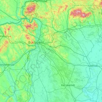
Name: Pest vármegye topographic map, elevation, terrain.
Location: Pest vármegye, Pest, Central Hungary, Hungary (46.67159 18.64526 48.07159 20.04526)
Average elevation: 156 m
Minimum elevation: 76 m
Maximum elevation: 1,010 m
Other topographic maps
Click on a map to view its topography, its elevation and its terrain.
Budapest
The wide Danube was always fordable at this point because of a small number of islands in the middle of the river. The city has marked topographical contrasts: Buda is built on the higher river terraces and hills of the western side, while the considerably larger Pest spreads out on a flat and featureless sand…
Average elevation: 171 m
Miskolc
Hungary > Borsod-Abaúj-Zemplén
The lowest areas are the banks of the river Sajó, with an altitude of 110–120 m (360–390 ft). The area belongs to the Great Plain region and is made up of sedimentary rocks. Between the Avas hill and Diósgyőr lies the hilly area of the Lower Bükk (250–300 m or 820–980 ft) consisting of sandstone,…
Average elevation: 194 m
Pécs
Pécs is bordered by plains to the south (elevation 120–130 m), while the Mecsek mountains rise up to elevations of 400–600 meters behind the city. Jakab-hill, located in the western Mecsek, is 592 m (1942 ft) tall, Tubes, straight above Pécs, is 612 m (2008 ft) tall, and Misina is 535 m (1755 ft) tall.…
Average elevation: 232 m