
Make a donation
Magdalena topographic map
Click on the map to display elevation.
Make a donation
Magdalena
The Department of Magdalena, because of its terrain, and proximity to the sea has an unstable weather. Its Climate is mainly dictated by its global positioning, and because the department of Magdalena is located on the Intertropical Convergence Zone it possess an inter-tropical climate. Temperature in the department is affected by ocean currents, precipitation and atmospheric pressure, it mainly has a hot temperatures with high humidity, but temperatures vary as altitude raises.
Make a donation
About this map
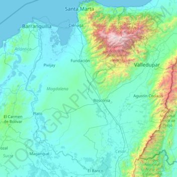
Name: Magdalena topographic map, elevation, terrain.
Location: Magdalena, RAP Caribe, Colombia (8.91711 -74.94559 11.34905 -73.54198)
Average elevation: 407 m
Minimum elevation: -1 m
Maximum elevation: 5,519 m
Make a donation
Other topographic maps
Click on a map to view its topography, its elevation and its terrain.
Tunja
Tunja has a population of 172,548 inhabitants according to the 2018 Census. 0.1% of the city is indigenous, 0.4% is black, and 99.5% is white and Mestizo. It is located in central Colombia, at an elevation ranging from approximately 2,700 metres (8,900 ft) to 2,900 metres (9,500 ft). The city centre is at an…
Average elevation: 2,824 m
Pacho
Pacho is a municipality and town of Colombia in the department of Cundinamarca. Pacho is part of the Rionegro Province and the urban centre is situated at a distance of 88 kilometres (55 mi) from the capital Bogotá at an altitude of 2,136 metres (7,008 ft), while the altitude ranges from 1,000 metres (3,300…
Average elevation: 1,881 m
Make a donation
Make a donation
Make a donation