
Hosford-Abernethy topographic map
Interactive map
Click on the map to display elevation.
About this map
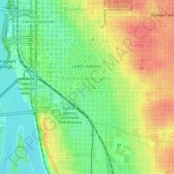
Name: Hosford-Abernethy topographic map, elevation, terrain.
Location: Hosford-Abernethy, Portland, Multnomah County, Oregon, USA (45.49732 -122.67094 45.51323 -122.63557)
Average elevation: 26 m
Minimum elevation: -2 m
Maximum elevation: 54 m
Other topographic maps
Click on a map to view its topography, its elevation and its terrain.
Eastmoreland
Eastmoreland, Portland, Multnomah County, Oregon, 97202, USA
Average elevation: 42 m
Hoyt Arboretum
Hoyt Arboretum, Arlington Heights, Portland, Multnomah County, Oregon, USA
Average elevation: 209 m
Powell Butte Nature Park
Powell Butte Nature Park, Pleasant Valley, Portland, Multnomah County, Oregon, USA
Average elevation: 123 m
Northwest District
Northwest District, Portland, Multnomah County, Oregon, 97210, USA
Average elevation: 52 m
Oaks Bottom Wildlife Refuge
Oaks Bottom Wildlife Refuge, Westmoreland, Sellwood-Moreland, Portland, Multnomah County, Oregon, USA
Average elevation: 17 m