
Thank you for supporting this site ❤️
Make a donation
Make a donation
Clapham topographic map
Click on the map to display elevation.
Thank you for supporting this site ❤️
Make a donation
Make a donation
About this map
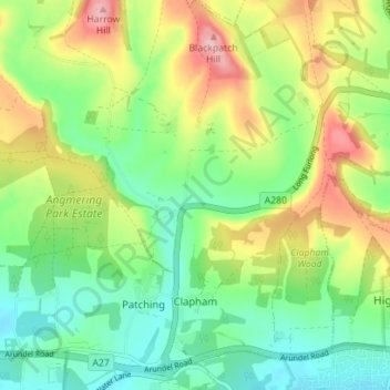
Name: Clapham topographic map, elevation, terrain.
Location: Clapham, Arun, West Sussex, England, United Kingdom (50.83622 -0.45338 50.88049 -0.42197)
Average elevation: 72 m
Minimum elevation: 14 m
Maximum elevation: 167 m
Thank you for supporting this site ❤️
Make a donation
Make a donation
Other topographic maps
Click on a map to view its topography, its elevation and its terrain.
Thank you for supporting this site ❤️
Make a donation
Make a donation
Thank you for supporting this site ❤️
Make a donation
Make a donation
Thank you for supporting this site ❤️
Make a donation
Make a donation