
Thank you for supporting this site ❤️
Make a donation
Make a donation
Aberdulais topographic map
Click on the map to display elevation.
Thank you for supporting this site ❤️
Make a donation
Make a donation
About this map
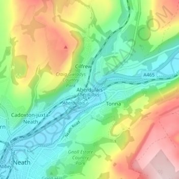
Name: Aberdulais topographic map, elevation, terrain.
Location: Aberdulais, Neath Port Talbot, Wales, SA10 8LE, United Kingdom (51.65914 -3.79941 51.69914 -3.75941)
Average elevation: 114 m
Minimum elevation: 2 m
Maximum elevation: 306 m
Thank you for supporting this site ❤️
Make a donation
Make a donation