
Thank you for supporting this site ❤️
Make a donation
Make a donation
Grad Pula topographic map
Click on the map to display elevation.
Thank you for supporting this site ❤️
Make a donation
Make a donation
About this map
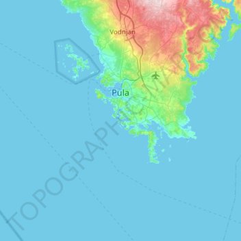
Name: Grad Pula topographic map, elevation, terrain.
Location: Grad Pula, Istria County, Croatia (44.82613 13.70967 44.94537 13.91682)
Average elevation: 40 m
Minimum elevation: -2 m
Maximum elevation: 194 m
Thank you for supporting this site ❤️
Make a donation
Make a donation
Other topographic maps
Click on a map to view its topography, its elevation and its terrain.
Thank you for supporting this site ❤️
Make a donation
Make a donation
Thank you for supporting this site ❤️
Make a donation
Make a donation
Thank you for supporting this site ❤️
Make a donation
Make a donation
Thank you for supporting this site ❤️
Make a donation
Make a donation
Thank you for supporting this site ❤️
Make a donation
Make a donation
Thank you for supporting this site ❤️
Make a donation
Make a donation
Thank you for supporting this site ❤️
Make a donation
Make a donation
Thank you for supporting this site ❤️
Make a donation
Make a donation
Thank you for supporting this site ❤️
Make a donation
Make a donation
Višnjan
Višnjan is located 12 kilometers east of Poreč and 3 kilometers west of Pula-Koper road. Višnjan is located on elevation of 244m and average municipality elevation is between 200-300m. One of the most notable sinkholes in Istria, Baredina, is located in the municipality.
Average elevation: 221 m