
Kasan topographic map
Interactive map
Click on the map to display elevation.
About this map
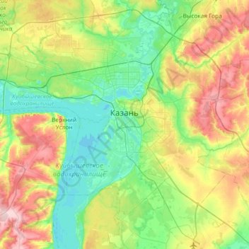
Name: Kasan topographic map, elevation, terrain.
Average elevation: 104 m
Minimum elevation: 45 m
Maximum elevation: 230 m
Other topographic maps
Click on a map to view its topography, its elevation and its terrain.
Танковое кольцо
Russland > Tatarstan > городской округ Казань > Kasan
Танковое кольцо, Калининский, Приволжский район, Kasan, городской округ Казань, Tatarstan, Föderationskreis Wolga, 420059, Russland
Average elevation: 71 m