
Santiago Metropolitan Region topographic map
Interactive map
Click on the map to display elevation.
Santiago Metropolitan Region
Most of the region is made up of an extremely fertile, level prairie that the locals call la Depresión intermedia (Intermediate Depression). The terrain is known for its low elevation in relation to sea level and for being surrounded by hills, as well as emergent so-called island hills, such as Santa Lucía (an ancient extinct volcano), Blanco, and Renca, present today in the city of Santiago.
About this map
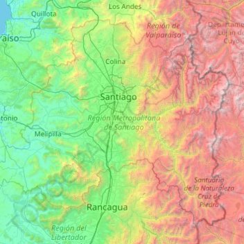
Name: Santiago Metropolitan Region topographic map, elevation, terrain.
Location: Santiago Metropolitan Region, Chile (-34.29200 -71.71485 -32.92217 -69.77023)
Average elevation: 1,721 m
Minimum elevation: 0 m
Maximum elevation: 6,540 m
Other topographic maps
Click on a map to view its topography, its elevation and its terrain.
Chicureo
Chile > Santiago Metropolitan Region > Provincia de Chacabuco > Colina
Average elevation: 711 m
Montenegro
Chile > Santiago Metropolitan Region > Provincia de Chacabuco > Tiltil
Average elevation: 836 m
Rinconada
Chile > Santiago Metropolitan Region > Provincia de Talagante > El Monte > El Paico Alto
Average elevation: 445 m
Cerro Torre
Chile > Magallanes and Chilean Antarctica Region > Provincia de Última Esperanza > Puerto Natales
Average elevation: 1,916 m
Atacama Desert
Chile > Antofagasta Region > Provincia de Antofagasta > Antofagasta
The Coastal Cliff of northern Chile west of the Chilean Coast Range is the main topographical feature of the coast. The geomorphology of the Atacama Desert has been characterized as a low-relief bench "similar to a giant uplifted terrace" by Armijo and co-workers. The intermediate depression (or Central…
Average elevation: 1,961 m
Punta Santa Ana
Chile > Region of Magallanes and Chilean Antarctica > Provincia de Magallanes > Punta Arenas
Average elevation: 5 m
Villa Cerro Castillo
Chile > Aysén Region > Provincia de General Carrera > Río Ibáñez
Average elevation: 379 m
Viña del Mar
Chile > Valparaiso Region > Provincia de Valparaíso > Viña del Mar
Average elevation: 152 m
Isla Isabela
Chile > XII Region of Magallanes and Chilean Antarctica > Punta Arenas
Average elevation: 6 m