
Thank you for supporting this site ❤️
Make a donation
Make a donation
Buladean topographic map
Click on the map to display elevation.
Thank you for supporting this site ❤️
Make a donation
Make a donation
About this map
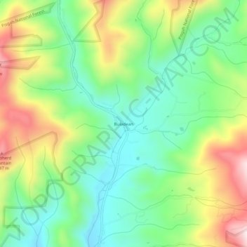
Name: Buladean topographic map, elevation, terrain.
Location: Buladean, Mitchell County, North Carolina, United States (36.08845 -82.21485 36.12845 -82.17485)
Average elevation: 992 m
Minimum elevation: 806 m
Maximum elevation: 1,301 m
Thank you for supporting this site ❤️
Make a donation
Make a donation
Other topographic maps
Click on a map to view its topography, its elevation and its terrain.
North Toe River
United States > North Carolina > Mitchell County > Spruce Pine
Average elevation: 824 m
Thank you for supporting this site ❤️
Make a donation
Make a donation