
Bâgé-la-Ville topographic map
Interactive map
Click on the map to display elevation.
About this map
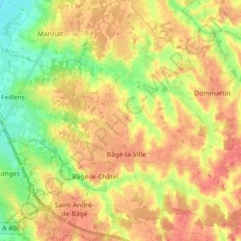
Name: Bâgé-la-Ville topographic map, elevation, terrain.
Average elevation: 198 m
Minimum elevation: 169 m
Maximum elevation: 219 m
Other topographic maps
Click on a map to view its topography, its elevation and its terrain.
Grand Champvent
France > Auvergne-Rhône-Alpes > Ain > Bâgé-Dommartin
Grand Champvent, Bâgé-la-Ville, Bâgé-Dommartin, Bourg-en-Bresse, Ain, Auvergne-Rhône-Alpes, France métropolitaine, 01380, France
Average elevation: 200 m