
Chester County topographic map
Click on the map to display elevation.
Chester County
Chester County lies within southeastern Pennsylvania’s Piedmont landscape, where the terrain is shaped by a sequence of rolling uplands, elongated ridges, and stream-cut valleys rather than by broad plains or high mountains. Its relief is especially varied across the northern and western parts of the county, where resistant metamorphic rocks form rounded hills and ridge belts such as Mine Ridge and the uplands around French Creek, while lower, more open corridors such as Chester Valley follow softer geologic zones. Elevations generally descend from the higher Piedmont uplands in the northwest and west toward the gentler lowlands and river-drained areas to the east and southeast, where streams such as the Brandywine, French, White Clay, Red Clay, Valley, and Schuylkill tributaries carve shallow to moderately incised valleys. Overall, the county presents a classic Piedmont topography: undulating agricultural and wooded hills, narrow valley floors, locally steep stream slopes, and a gradual transition toward the lower Delaware River basin and the Philadelphia-area lowlands.
About this map
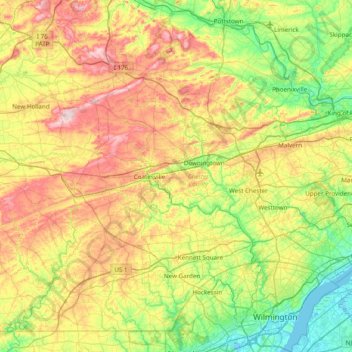
Name: Chester County topographic map, elevation, terrain.
Location: Chester County, Pennsylvania, United States (39.72149 -76.13658 40.24509 -75.36105)
Average elevation: 124 m
Minimum elevation: -5 m
Maximum elevation: 336 m
Other topographic maps
Click on a map to view its topography, its elevation and its terrain.
Fogelsville
United States > Pennsylvania > Lehigh County > Upper Macungie Township
Average elevation: 155 m
Orefield
United States > Pennsylvania > Lehigh County > North Whitehall Township
Average elevation: 141 m
Fort Hill
United States > Pennsylvania > Somerset County > Upper Turkeyfoot Township
Average elevation: 556 m
Analomink
United States > Pennsylvania > Monroe County > Stroud Township > Penn Estates
Average elevation: 235 m
Pipersville
United States > Pennsylvania > Bucks County > Bedminster Township
Average elevation: 125 m
Lake Keystone
United States > Pennsylvania > Armstrong County > Plumcreek Township
Keystone Lake (also known as Keystone Reservoir and Plum Creek Reservoir) is a reservoir in Armstrong County in the U.S. state of Pennsylvania. The elevation of Keystone Lake is 1,076 feet (328 m) above sea level.
Average elevation: 357 m
Pocono Lake
United States > Pennsylvania > Monroe County > Tobyhanna Township
Average elevation: 543 m
Valley Forge
United States > Pennsylvania > Chester County > Schuylkill Township
Average elevation: 78 m
Bald Mountain
United States > Pennsylvania > Luzerne County > Bear Creek Township
Average elevation: 555 m
East Texas
United States > Pennsylvania > Lehigh County > Lower Macungie Township
Average elevation: 126 m
Pocono Summit
United States > Pennsylvania > Monroe County > Tobyhanna Township
Average elevation: 550 m
Lords Valley
United States > Pennsylvania > Pike County > Blooming Grove Township
Average elevation: 412 m
Lake Carey
United States > Pennsylvania > Wyoming County > Lemon Township > Lemon > Lake Carey
Average elevation: 323 m
Mount Misery
United States > Pennsylvania > Chester County > Tredyffrin Township
Average elevation: 103 m
Dingmans Ferry
United States > Pennsylvania > Pike County > Delaware Township
Average elevation: 192 m
Mount Nebo Park
United States > Pennsylvania > Monroe County > East Stroudsburg > Twin Falls
Average elevation: 185 m
Cowden
United States > Pennsylvania > Washington County > Cecil Township > Cecil
Average elevation: 346 m
Keown Station
United States > Pennsylvania > Allegheny County > Ross Township
Average elevation: 344 m
New Enterprise
United States > Pennsylvania > Bedford County > South Woodbury Township
Average elevation: 397 m
Blue Knob
United States > Pennsylvania > Bedford County > Pavia Township
Blue Knob (elevation 3,146 feet (959 m)) is a summit in the eastern United States with a broad dome that is the northernmost 3,000-footer in the Allegheny Mountains. It is the highest point in Bedford County, Pennsylvania.
Average elevation: 792 m
Sinnemahoning
United States > Pennsylvania > Cameron County > Gibson Township
Average elevation: 406 m
Saint Benedict
United States > Pennsylvania > Cambria County > West Carroll Township
Average elevation: 582 m
English Center
United States > Pennsylvania > Lycoming County > Pine Township
Average elevation: 444 m
Tyrrel Farm Corners
United States > Pennsylvania > Venango County > Allegheny Township
Average elevation: 478 m
Fort Hunter
United States > Pennsylvania > Dauphin County > Middle Paxton Township
Average elevation: 149 m
Green Village
United States > Pennsylvania > Franklin County > Greene Township
Average elevation: 207 m
Normalville
United States > Pennsylvania > Fayette County > Springfield Township
Average elevation: 486 m
Arnold City
United States > Pennsylvania > Fayette County > Washington Township
Average elevation: 303 m
Three Tuns
United States > Pennsylvania > Montgomery County > Upper Dublin Township > Maple Glen
Average elevation: 101 m
Hidden Valley
United States > Pennsylvania > Montgomery County > Upper Merion Township
Average elevation: 47 m
Strafford
United States > Pennsylvania > Chester County > Tredyffrin Township
Average elevation: 133 m
West Pittsburg
United States > Pennsylvania > Lawrence County > Taylor Township
Average elevation: 279 m
Dilltown
United States > Pennsylvania > Indiana County > East Wheatfield Township
Average elevation: 474 m
Robinson
United States > Pennsylvania > Indiana County > West Wheatfield Township
Average elevation: 397 m
Hazelton Mills
United States > Pennsylvania > McKean County > Bradford Township
Average elevation: 598 m
Mount Bethel
United States > Pennsylvania > Northampton County > Upper Mount Bethel Township
Average elevation: 156 m
Rosemount
United States > Pennsylvania > York County > Spring Garden Township
Average elevation: 167 m
Reservoir Heights
United States > Pennsylvania > Dauphin County > Upper Paxton Township
Average elevation: 189 m
Skytop
United States > Pennsylvania > Monroe County > Barrett Township
Skytop is an unincorporated community in Barrett Township, Monroe County, Pennsylvania, United States. Located north of Mountainhome, it is accessible by local roads off Route 390. Its elevation is 1,562 feet (476 m), and it is located at 41°13′40″N 75°14′18″W / 41.22778°N 75.23833°W /…
Average elevation: 469 m
Ricketts Glen State Park
United States > Pennsylvania > Luzerne County > Fairmount Township
The state's original plans for the new park included building an inn, an 18-hole golf course and country club, and a winter sports complex for skiing, ice boating, and tobogganing, as well as a beach with bathing facilities, cabins, and a tent camping area. Only the last three were actually built, all south of…
Average elevation: 588 m
Mount Cobb
United States > Pennsylvania > Lackawanna County > Jefferson Township
Average elevation: 529 m
Pastorius Park
United States > Pennsylvania > Philadelphia County > Philadelphia
Average elevation: 108 m
Danielsville
United States > Pennsylvania > Northampton County > Lehigh Township
Average elevation: 254 m
Blue Mountain
United States > Pennsylvania > Monroe County > Eldred Township
The ridge of Blue Mountain runs for 150 miles (240 km) through Pennsylvania, reaching an elevation of 2,270 feet (690 m) above sea level just north of the Pennsylvania Turnpike, near the borough of Newburg. Most of the ridgecrest, however, only reaches between 1,400 and 1,700 feet (430 and 520 m) in elevation.…
Average elevation: 242 m
Park Place
United States > Pennsylvania > Schuylkill County > Mahanoy Township
Average elevation: 515 m
Portlamd Waterfront Park
United States > Pennsylvania > Northampton County > Portland
Average elevation: 118 m
Stevens Point
United States > Pennsylvania > Susquehanna County > Harmony Township
Average elevation: 434 m
Pendle Hill
United States > Pennsylvania > Delaware County > Nether Providence Township
Average elevation: 61 m
Longwood Gardens
United States > Pennsylvania > Chester County > East Marlborough Township
Average elevation: 125 m
Nottingham County Park
United States > Pennsylvania > Chester County > West Nottingham Township
Average elevation: 137 m