
Make a donation
York Township topographic map
Click on the map to display elevation.
Make a donation
About this map
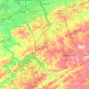
Name: York Township topographic map, elevation, terrain.
Location: York Township, York County, Pennsylvania, United States (39.87032 -76.76419 39.96091 -76.59812)
Average elevation: 189 m
Minimum elevation: 61 m
Maximum elevation: 309 m
Make a donation
Other topographic maps
Click on a map to view its topography, its elevation and its terrain.
Rosemount
United States > Pennsylvania > York County > Spring Garden Township
Average elevation: 167 m
Make a donation
Hanover Junction
United States > Pennsylvania > York County > North Codorus Township
Average elevation: 187 m
Strickhousers
United States > Pennsylvania > York County > North Codorus Township
Average elevation: 205 m
Make a donation
Bass Lake
United States > Pennsylvania > York County > Newberry Township > Valley Green
Average elevation: 143 m
Starview
United States > Pennsylvania > York County > East Manchester Township
Average elevation: 155 m
Pleasureville
United States > Pennsylvania > York County > Springettsbury Township
Average elevation: 145 m
Make a donation
East York
United States > Pennsylvania > York County > Springettsbury Township
Average elevation: 143 m
Make a donation
Stoverstown
United States > Pennsylvania > York County > North Codorus Township
Average elevation: 171 m
Spring Plains
United States > Pennsylvania > York County > Springettsbury Township
Average elevation: 151 m
Spring Plains
United States > Pennsylvania > York County > Springettsbury Township
Average elevation: 151 m
Make a donation
Delta Ridge
United States > Pennsylvania > York County > Peach Bottom Township
Average elevation: 150 m
Make a donation
Ore Valley
United States > Pennsylvania > York County > York Township > Ore Valley
Average elevation: 202 m
Make a donation