
Thank you for supporting this site ❤️
Make a donation
Make a donation
Walcha topographic map
Click on the map to display elevation.
Thank you for supporting this site ❤️
Make a donation
Make a donation
About this map
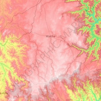
Name: Walcha topographic map, elevation, terrain.
Location: Walcha, Walcha Council, New South Wales, 2354, Australia (-31.45195 151.30351 -30.75713 152.29545)
Average elevation: 956 m
Minimum elevation: 170 m
Maximum elevation: 1,450 m
Thank you for supporting this site ❤️
Make a donation
Make a donation
Other topographic maps
Click on a map to view its topography, its elevation and its terrain.
Thank you for supporting this site ❤️
Make a donation
Make a donation
Thank you for supporting this site ❤️
Make a donation
Make a donation
Thank you for supporting this site ❤️
Make a donation
Make a donation
Thank you for supporting this site ❤️
Make a donation
Make a donation