
Thank you for supporting this site ❤️
Make a donation
Make a donation
Silver Lake topographic map
Click on the map to display elevation.
Thank you for supporting this site ❤️
Make a donation
Make a donation
About this map
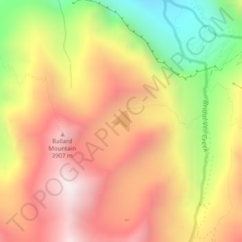
Name: Silver Lake topographic map, elevation, terrain.
Location: Silver Lake, San Miguel County, Colorado, United States (37.91219 -107.78341 37.91460 -107.78068)
Average elevation: 3,459 m
Minimum elevation: 2,768 m
Maximum elevation: 3,998 m
Thank you for supporting this site ❤️
Make a donation
Make a donation
Other topographic maps
Click on a map to view its topography, its elevation and its terrain.
Telluride
United States > Colorado > San Miguel County > Telluride
Telluride has an elevation of 8,750 feet (2,670 m) in an isolated spot in Southwest Colorado. From the west, Colorado Route 145 is the most common way into Telluride; two other passes enter the town, Imogene Pass and Black Bear Pass.
Average elevation: 3,246 m