
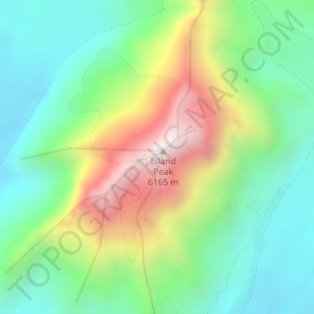
Island Peak topographic map
Interactive map
Click on the map to display elevation.
About this map
Name: Island Peak topographic map, elevation, terrain.
Average elevation: 5,461 m
Minimum elevation: 5,108 m
Maximum elevation: 6,131 m
Other topographic maps
Click on a map to view its topography, its elevation and its terrain.
सगरमाथा - Everest
Népal > Région de développement Est > Khumjung
सगरमाथा - Everest, Khumjung, सोलुखुम्बु, सगरमाथा अञ्चल, Région de développement Est, Népal
Average elevation: 7,841 m
Lhotse Shar
Népal > Région de développement Est > Khumjung
Lhotse Shar, Khumjung, सोलुखुम्बु, सगरमाथा अञ्चल, Région de développement Est, Népal
Average elevation: 7,153 m
ग्याचुङ काङ 格重康峰 Gyachung Kang
Népal > Région de développement Est > Khumjung
ग्याचुङ काङ 格重康峰 Gyachung Kang, Khumjung, सोलुखुम्बु, सगरमाथा अञ्चल, Région de développement Est, Népal
Average elevation: 7,006 m