
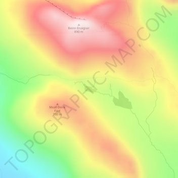
Loch Bealach nam Buthan topographic map
Interactive map
Click on the map to display elevation.
About this map
Name: Loch Bealach nam Buthan topographic map, elevation, terrain.
Average elevation: 586 m
Minimum elevation: 232 m
Maximum elevation: 889 m
Other topographic maps
Click on a map to view its topography, its elevation and its terrain.
Glencoe
Verenigd Koninkrijk > Schotland > Highland
Glencoe, Highland, Schotland, PH49 4HS, Verenigd Koninkrijk
Average elevation: 114 m
Glen Coe
Verenigd Koninkrijk > Schotland > Highland > Glencoe
Glen Coe, Glencoe, Highland, Schotland, Verenigd Koninkrijk
Average elevation: 414 m
Glen Etive
Verenigd Koninkrijk > Schotland > Highland
Glen Etive, Highland, Schotland, Verenigd Koninkrijk
Average elevation: 477 m
River Etive
Verenigd Koninkrijk > Schotland > Highland
River Etive, Highland, Schotland, Verenigd Koninkrijk
Average elevation: 331 m
Scottish Highlands
Verenigd Koninkrijk > Schotland > Highland
Scottish Highlands, Highland, Schotland, Verenigd Koninkrijk
Average elevation: 907 m
Portree - Port Rìgh
Verenigd Koninkrijk > Schotland > Highland
Portree - Port Rìgh, Highland, Schotland, IV51 9EH, Verenigd Koninkrijk
Average elevation: 121 m
Aviemore
Verenigd Koninkrijk > Schotland > Highland > Aviemore
Aviemore, Highland, Schotland, PH22 1RN, Verenigd Koninkrijk
Average elevation: 331 m
Stein
Verenigd Koninkrijk > Schotland > Highland > Stein
Stein, Highland, Schotland, IV55 8GA, Verenigd Koninkrijk
Average elevation: 98 m
Ben Nevis
Verenigd Koninkrijk > Schotland > Highland
Ben Nevis, Highland, Schotland, Verenigd Koninkrijk
Average elevation: 912 m