
Rodenhausen topographic map
Interactive map
Click on the map to display elevation.
About this map
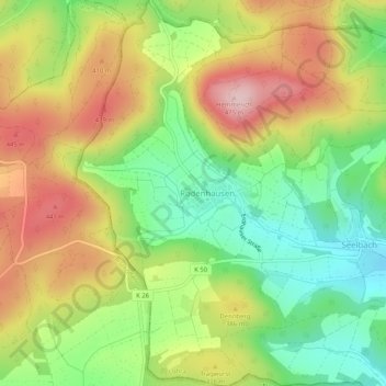
Name: Rodenhausen topographic map, elevation, terrain.
Average elevation: 347 m
Minimum elevation: 236 m
Maximum elevation: 474 m
Other topographic maps
Click on a map to view its topography, its elevation and its terrain.
Kirchvers
Deutschland > Hessen > Landkreis Marburg-Biedenkopf > Lohra
Kirchvers, Lohra, Landkreis Marburg-Biedenkopf, Hessen, Deutschland
Average elevation: 259 m