
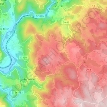
Aubazines topographic map
Interactive map
Click on the map to display elevation.
About this map
Name: Aubazines topographic map, elevation, terrain.
Average elevation: 355 m
Minimum elevation: 131 m
Maximum elevation: 548 m
The lowest altitude of the commune is 126 metres in the west where the Corrèze leaves the commune. The highest points are 520 metres high on the Puy de Pauliac which dominates the area, and in the south-east next to Le Chastang near a place called la Jarouste.
Other topographic maps
Click on a map to view its topography, its elevation and its terrain.
Lignareix
France > Nouvelle-Aquitaine > Corrèze
Lignareix, Ussel, Corrèze, Nouvelle-Aquitaine, Metropolitan France, 19200, France
Average elevation: 709 m
Curemonte
France > Nouvelle-Aquitaine > Corrèze
Curemonte, Brive-la-Gaillarde, Corrèze, Nouvelle-Aquitaine, Metropolitan France, 19500, France
Average elevation: 186 m
Peyrelevade
France > Nouvelle-Aquitaine > Corrèze
Peyrelevade, Ussel, Corrèze, Nouvelle-Aquitaine, Metropolitan France, 19290, France
Average elevation: 824 m
Lubersac
France > Nouvelle-Aquitaine > Corrèze
Lubersac, Brive-la-Gaillarde, Corrèze, Nouvelle-Aquitaine, Metropolitan France, 19210, France
Average elevation: 362 m
Sainte-Féréole
France > Nouvelle-Aquitaine > Corrèze
Sainte-Féréole, Brive-la-Gaillarde, Corrèze, Nouvelle-Aquitaine, Metropolitan France, 19270, France
Average elevation: 302 m
Liginiac
France > Nouvelle-Aquitaine > Corrèze
Liginiac, Ussel, Corrèze, Nouvelle-Aquitaine, Metropolitan France, 19160, France
Average elevation: 595 m
Argentat
France > Nouvelle-Aquitaine > Corrèze > Argentat-sur-Dordogne
Argentat, Argentat-sur-Dordogne, Tulle, Corrèze, Nouvelle-Aquitaine, Metropolitan France, 19400, France
Average elevation: 313 m
Roche-le-Peyroux
France > Nouvelle-Aquitaine > Corrèze
Roche-le-Peyroux, Ussel, Corrèze, Nouvelle-Aquitaine, Metropolitan France, 19160, France
Average elevation: 567 m
Brignac-la-Plaine
France > Nouvelle-Aquitaine > Corrèze
Brignac-la-Plaine, Brive-la-Gaillarde, Corrèze, Nouvelle-Aquitaine, Metropolitan France, 19310, France
Average elevation: 177 m
Lagarde-Marc-la-Tour
France > Nouvelle-Aquitaine > Corrèze
Lagarde-Marc-la-Tour, Tulle, Corrèze, Nouvelle-Aquitaine, Metropolitan France, 19150, France
Average elevation: 430 m
Lostanges
France > Nouvelle-Aquitaine > Corrèze
Lostanges, Brive-la-Gaillarde, Corrèze, Nouvelle-Aquitaine, Metropolitan France, 19500, France
Average elevation: 320 m
Saint-Bazile-de-la-Roche
France > Nouvelle-Aquitaine > Corrèze > Argentat-sur-Dordogne
Saint-Bazile-de-la-Roche, Argentat-sur-Dordogne, Tulle, Corrèze, Nouvelle-Aquitaine, Metropolitan France, France
Average elevation: 397 m
Feintrain
France > Nouvelle-Aquitaine > Corrèze > Darazac
Feintrain, Darazac, Tulle, Corrèze, Nouvelle-Aquitaine, Metropolitan France, 19220, France
Average elevation: 566 m
Darazac
France > Nouvelle-Aquitaine > Corrèze
Darazac, Tulle, Corrèze, Nouvelle-Aquitaine, Metropolitan France, 19220, France
Average elevation: 555 m
Saint-Geniez-ô-Merle
France > Nouvelle-Aquitaine > Corrèze
Saint-Geniez-ô-Merle, Tulle, Corrèze, Nouvelle-Aquitaine, Metropolitan France, 19220, France
Average elevation: 472 m
Ussel
France > Nouvelle-Aquitaine > Corrèze
Ussel, Corrèze, Nouvelle-Aquitaine, Metropolitan France, 19200, France
Average elevation: 680 m
Bonnefond
France > Nouvelle-Aquitaine > Corrèze
Bonnefond, Tulle, Corrèze, Nouvelle-Aquitaine, Metropolitan France, 19170, France
Average elevation: 827 m
Naves
France > Nouvelle-Aquitaine > Corrèze
Naves, Tulle, Corrèze, Nouvelle-Aquitaine, Metropolitan France, 19460, France
Average elevation: 378 m
Brive-la-Gaillarde
France > Nouvelle-Aquitaine > Corrèze
Brive-la-Gaillarde, Corrèze, Nouvelle-Aquitaine, Metropolitan France, 19100, France
Average elevation: 178 m
Soudaine-Lavinadière
France > Nouvelle-Aquitaine > Corrèze
Soudaine-Lavinadière, Tulle, Corrèze, Nouvelle-Aquitaine, Metropolitan France, 19370, France
Average elevation: 453 m
La Moutade
France > Nouvelle-Aquitaine > Corrèze > Peyrelevade
La Moutade, Peyrelevade, Ussel, Corrèze, Nouvelle-Aquitaine, Metropolitan France, 19290, France
Average elevation: 802 m
Masseret
France > Nouvelle-Aquitaine > Corrèze
Masseret, Tulle, Corrèze, Nouvelle-Aquitaine, Metropolitan France, 19510, France
Average elevation: 442 m
Noailles
France > Nouvelle-Aquitaine > Corrèze
Noailles, Brive-la-Gaillarde, Corrèze, Nouvelle-Aquitaine, Metropolitan France, 19600, France
Average elevation: 243 m
Lacombe
France > Nouvelle-Aquitaine > Corrèze > Curemonte
Lacombe, Curemonte, Brive-la-Gaillarde, Corrèze, Nouvelle-Aquitaine, Metropolitan France, 19500, France
Average elevation: 167 m
La Meynarde
France > Nouvelle-Aquitaine > Corrèze > Turenne
La Meynarde, Turenne, Brive-la-Gaillarde, Corrèze, Nouvelle-Aquitaine, Metropolitan France, 19500, France
Average elevation: 260 m
Le Bois de Phili
France > Nouvelle-Aquitaine > Corrèze > Uzerche
Le Bois de Phili, Uzerche, Tulle, Corrèze, Nouvelle-Aquitaine, Metropolitan France, 19140, France
Average elevation: 376 m
Égletons
France > Nouvelle-Aquitaine > Corrèze
Égletons, Ussel, Corrèze, Nouvelle-Aquitaine, Metropolitan France, 19300, France
Average elevation: 624 m
Saint-Robert
France > Nouvelle-Aquitaine > Corrèze
Saint-Robert, Brive-la-Gaillarde, Corrèze, Nouvelle-Aquitaine, Metropolitan France, 19310, France
Average elevation: 256 m
Aubazine
France > Nouvelle-Aquitaine > Corrèze > Aubazines
Aubazine, Aubazines, Brive-la-Gaillarde, Corrèze, Nouvelle-Aquitaine, Metropolitan France, 19190, France
Average elevation: 317 m
Turenne
France > Nouvelle-Aquitaine > Corrèze
Turenne, Brive-la-Gaillarde, Corrèze, Nouvelle-Aquitaine, Metropolitan France, 19500, France
Average elevation: 286 m
Tarnac
France > Nouvelle-Aquitaine > Corrèze
Tarnac, Tulle, Corrèze, Nouvelle-Aquitaine, Metropolitan France, 19170, France
Average elevation: 732 m