
Make a donation
Rogerson topographic map
Click on the map to display elevation.
Make a donation
About this map
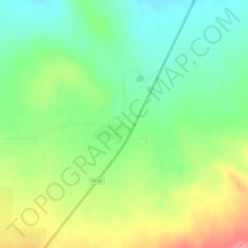
Name: Rogerson topographic map, elevation, terrain.
Location: Rogerson, Twin Falls County, Idaho, 83302, United States (42.19797 -114.61420 42.23797 -114.57420)
Average elevation: 1,498 m
Minimum elevation: 1,462 m
Maximum elevation: 1,552 m
Make a donation
Other topographic maps
Click on a map to view its topography, its elevation and its terrain.
Make a donation
Buhl
United States > Idaho > Twin Falls County
Buhl is located at 42°36′0″N 114°45′43″W / 42.60000°N 114.76194°W / 42.60000; -114.76194 (42.600102, -114.761867), at an elevation of 3,770 feet (1,149 m) above sea level.
Average elevation: 1,149 m
Filer
United States > Idaho > Twin Falls County
Filer is located at 42°34′11″N 114°36′41″W / 42.56972°N 114.61139°W / 42.56972; -114.61139 (42.569814, -114.611313), at an elevation of 3,766 feet (1,148 m) above sea level.
Average elevation: 1,149 m
Kimberly
United States > Idaho > Twin Falls County
Kimberly is located at 42°31′59″N 114°21′50″W / 42.53306°N 114.36389°W / 42.53306; -114.36389 (42.533169, -114.364022), at an elevation of 3,924 feet (1,196 m) above sea level.
Average elevation: 1,195 m
Make a donation