Geolocate

Nieuw Bergen topographic map

Click on the map to display elevation.

About this map

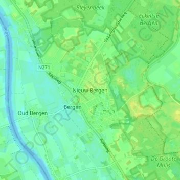
Name: Nieuw Bergen topographic map, elevation, terrain.

Location: Nieuw Bergen, Bergen, Limburg, Netherlands, 5854 BL, Netherlands (51.58497 6.03315 51.62497 6.07315)

Average elevation: 16 m

Minimum elevation: 9 m

Maximum elevation: 24 m

Other topographic maps

Click on a map to view its topography, its elevation and its terrain.

Landgraaf

Netherlands > Limburg

Dutch topographic map of the municipality of Landgraaf, June 2015

Average elevation: 126 m

Maastricht

Netherlands > Limburg

Average elevation: 72 m

Holtum

Netherlands > Limburg

Average elevation: 33 m

Kasteel Rivieren

Netherlands > Limburg > Klimmen > Weustenrade

Average elevation: 87 m

Weert

Netherlands > Limburg

Average elevation: 33 m

Venray

Netherlands > Limburg

Average elevation: 26 m

Windraak

Netherlands > Limburg

Average elevation: 90 m

Vaals

Netherlands > Limburg

Average elevation: 198 m

Stein

Netherlands > Limburg

Average elevation: 53 m

Vaals

Netherlands > Limburg

Average elevation: 198 m

Vijlen

Netherlands > Limburg

Average elevation: 190 m

Epen

Netherlands > Limburg

Average elevation: 169 m

Posterholt

Netherlands > Limburg

Average elevation: 33 m

Geulle

Netherlands > Limburg

Average elevation: 75 m

Helden

Netherlands > Limburg

Average elevation: 32 m

Landgraaf

Netherlands > Limburg

Dutch topographic map of the municipality of Landgraaf, June 2015

Average elevation: 126 m

Valkenburg aan de Geul

Netherlands > Limburg

Average elevation: 119 m

Brunssum

Netherlands > Limburg

Average elevation: 90 m

Amstenrade

Netherlands > Limburg

Average elevation: 98 m

Well

Netherlands > Limburg

Average elevation: 18 m

Vaals

Netherlands > Limburg

Average elevation: 226 m

Maastricht

Netherlands > Limburg

Average elevation: 73 m

Baarlo

Netherlands > Limburg

Average elevation: 24 m

Venray

Netherlands > Limburg

Average elevation: 26 m

Panningen

Netherlands > Limburg

Average elevation: 34 m

Roosteren

Netherlands > Limburg

Average elevation: 30 m

Schinveld

Netherlands > Limburg

Average elevation: 72 m

Meuse

Netherlands > Limburg > Baarlo

Average elevation: 22 m

Venlo

Netherlands > Limburg

Average elevation: 32 m

Maastricht

Netherlands > Limburg

Average elevation: 73 m

Wilhelminapark

Netherlands > Limburg > Venlo

Average elevation: 23 m

Valkenburg

Netherlands > Limburg

Average elevation: 123 m

Kerkrade

Netherlands > Limburg

Average elevation: 139 m

Sittard

Netherlands > Limburg

Average elevation: 52 m

Mook

Netherlands > Limburg

Average elevation: 29 m

Cadier en Keer

Netherlands > Limburg

Average elevation: 115 m

Gulpen

Netherlands > Limburg

Average elevation: 141 m

Weert

Netherlands > Limburg

Average elevation: 33 m

Bunde

Netherlands > Limburg

Average elevation: 60 m

Vaals

Netherlands > Limburg

Average elevation: 198 m

Meuse

Netherlands > Limburg > Baarlo

Average elevation: 22 m

Sevenum

Netherlands > Limburg

Average elevation: 29 m

Maastricht

Netherlands > Limburg

Average elevation: 73 m

Urmond

Netherlands > Limburg

Average elevation: 43 m

Maasbracht

Netherlands > Limburg

Average elevation: 25 m

Arcen

Netherlands > Limburg

Average elevation: 20 m

Kessel

Netherlands > Limburg

Average elevation: 27 m

Maasbree

Netherlands > Limburg

Average elevation: 29 m

Meijel

Netherlands > Limburg

Average elevation: 32 m

Heerlen

Netherlands > Limburg

Heerlen's high elevation makes it one of the highest cities above sea level in the Netherlands.

Average elevation: 131 m

Maastricht

Netherlands > Limburg

Average elevation: 73 m

Hoensbroek

Netherlands > Limburg

Average elevation: 90 m

Voerendaal

Netherlands > Limburg

Dutch topographic map of the municipality of Voerendaal, June 2015

Average elevation: 122 m

Nuth

Netherlands > Limburg

Average elevation: 95 m

Oirsbeek

Netherlands > Limburg

Average elevation: 96 m

Maastricht

Netherlands > Limburg

Average elevation: 73 m

Koningsbosch

Netherlands > Limburg

Average elevation: 55 m

Eygelshoven

Netherlands > Limburg

Average elevation: 118 m

Ysselsteyn

Netherlands > Limburg

Average elevation: 31 m

Maastricht-Airport

Netherlands > Limburg

Average elevation: 112 m

Siebengewald

Netherlands > Limburg

Average elevation: 17 m

Eijsden-Margraten

Netherlands > Limburg

Average elevation: 115 m

Brunssum

Netherlands > Limburg

Average elevation: 90 m

Roermond

Netherlands > Limburg

Average elevation: 25 m

Heerlen

Netherlands > Limburg > Heerlen

Heerlen's high elevation makes it one of the highest cities above sea level in the Netherlands.

Average elevation: 131 m

Reuver

Netherlands > Limburg

Average elevation: 27 m

Venlo

Netherlands > Limburg > Venlo

Average elevation: 27 m

Meuse

Netherlands > Limburg > Maastricht > Borgharen

Average elevation: 48 m

Sittard

Netherlands > Limburg

Average elevation: 52 m

Maastricht

Netherlands > Limburg

Average elevation: 72 m

Zuid-Limburg

Netherlands > Limburg

Average elevation: 101 m

Simpelveld

Netherlands > Limburg

Average elevation: 173 m

Gennep

Netherlands > Limburg > Gennep

Average elevation: 13 m

Geul

Netherlands > Limburg

Average elevation: 160 m

Valkenburg

Netherlands > Limburg

Average elevation: 123 m

Herkenbosch

Netherlands > Limburg > Herkenbosch

Average elevation: 38 m

Roermond

Netherlands > Limburg

Average elevation: 25 m

Castenray

Netherlands > Limburg

Average elevation: 25 m

Born

Netherlands > Limburg

Average elevation: 34 m

Limbricht

Netherlands > Limburg > Limbricht

Average elevation: 42 m

Swalmen

Netherlands > Limburg > Swalmen

Average elevation: 26 m

Eijsden

Netherlands > Limburg

Average elevation: 73 m

Kerkrade

Netherlands > Limburg

Average elevation: 140 m

Elsloo

Netherlands > Limburg > Elsloo

Average elevation: 67 m

Geleen

Netherlands > Limburg

Average elevation: 63 m