Geolocate

Mérida topographic map

Interactive map

Click on the map to display elevation.

About this map

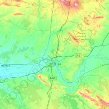
Name: Mérida topographic map, elevation, terrain.

Location: Mérida, Badajoz, Extremadura, Spain (38.72689 -6.65702 39.18170 -6.14057)

Average elevation: 292 m

Minimum elevation: 184 m

Maximum elevation: 683 m

Other topographic maps

Click on a map to view its topography, its elevation and its terrain.

Toril

Spain > Extremadura

Average elevation: 273 m

Padre Jacinto

Spain > Extremadura > Segura de León

Average elevation: 488 m

Alcántara

Spain > Extremadura > Cáceres > Alcántara

Average elevation: 312 m

Almendral

Spain > Extremadura > Almendral

Average elevation: 361 m

Belloto

Spain > Extremadura > Campanario

Average elevation: 414 m

Cáceres

Spain > Extremadura

Average elevation: 389 m