Geolocate

Harare topographic map

Interactive map

Click on the map to display elevation.

About this map

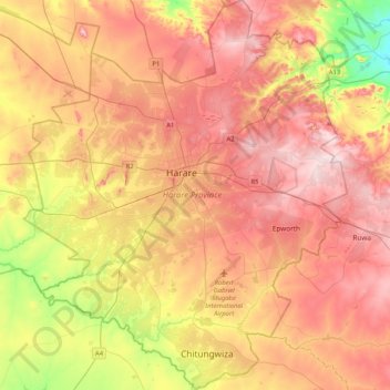
Name: Harare topographic map, elevation, terrain.

Location: Harare, Zimbabwe (-18.05099 30.87743 -17.65716 31.22145)

Average elevation: 1,461 m

Minimum elevation: 1,281 m

Maximum elevation: 1,603 m

Harare (/həˈrɑːreɪ/ hə-RAR-ay), formerly known as Salisbury (/ˈsɔːlzbəri/ SAWLZ-bər-ee), is the capital and largest city of Zimbabwe, and is the most populous city in the country. The city proper has an area of 982.3km2 (378.7 mi2), a population of 1,849,600 as of the 2022 census and an estimated 2,487,209 people in its metropolitan province. The city is situated in north-eastern Zimbabwe in the country's Mashonaland region. Harare is a metropolitan province, which also incorporates the municipalities of Chitungwiza and Epworth. The city sits on a plateau at an elevation of 1,483 metres (4,865 feet) above sea level, and its climate falls into the subtropical highland category.

Wikipedia (CC-BY-SA 3.0)

Other topographic maps

Click on a map to view its topography, its elevation and its terrain.

Manicaland Province

Zimbabwe

Manicaland Province, Zimbabwe

Average elevation: 784 m

Masvingo Province

Zimbabwe

Masvingo Province, Zimbabwe

Average elevation: 700 m

Mutasa

Zimbabwe > Manicaland Province

Mutasa, Manicaland Province, Zimbabwe

Average elevation: 1,262 m

Runanga

Zimbabwe > Mashonaland East Province > Goromonzi

Runanga, Goromonzi, Mashonaland East Province, Zimbabwe

Average elevation: 1,500 m

Shurugwi

Zimbabwe > Midlands

Shurugwi, Midlands, Zimbabwe

Average elevation: 1,182 m

Mashonaland Central Province

Zimbabwe

Mashonaland Central Province, Zimbabwe

Average elevation: 859 m

Bulawayo

Zimbabwe > Bulawayo Province > Bulawayo

Bulawayo, Bulawayo Province, Zimbabwe

Average elevation: 1,348 m

Mount Nyangani

Zimbabwe > Manicaland

Mount Nyangani, Nyanga, Manicaland, Zimbabwe

Average elevation: 2,329 m

Zaka

Zimbabwe > Masvingo > Zaka

Zaka, Masvingo, Zimbabwe

Average elevation: 757 m

Lake Chivero

Zimbabwe > Mashonaland West

Lake Chivero, Kamba Caravan Park Acces Road, Zvimba, Mashonaland West, Zimbabwe

Average elevation: 1,382 m

Mwenezi

Zimbabwe > Masvingo

Mwenezi, Masvingo, Zimbabwe

Average elevation: 573 m

Mutare

Zimbabwe > Manicaland

Mutare, Manicaland, Zimbabwe

Average elevation: 996 m