
Thank you for supporting this site ❤️
Make a donation
Make a donation
Belmont topographic map
Click on the map to display elevation.
Thank you for supporting this site ❤️
Make a donation
Make a donation
Belmont
Belmont has been referred to as a "Mormon enclave" due to the location of the Boston Massachusetts Temple of the LDS Church at the highest elevation in the town. The prominent gold statue of the Angel Moroni atop the Temple was originally designed by Cyrus Dallin in nearby Arlington, Massachusetts.
Thank you for supporting this site ❤️
Make a donation
Make a donation
About this map
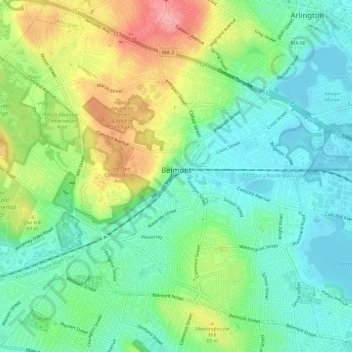
Name: Belmont topographic map, elevation, terrain.
Location: Belmont, Middlesex County, Massachusetts, United States (42.37506 -71.21195 42.41532 -71.15224)
Average elevation: 40 m
Minimum elevation: -1 m
Maximum elevation: 115 m
Thank you for supporting this site ❤️
Make a donation
Make a donation
Other topographic maps
Click on a map to view its topography, its elevation and its terrain.
Arlington Heights
United States > Massachusetts > Middlesex County > Arlington
Average elevation: 58 m