
Burnley topographic map
Interactive map
Click on the map to display elevation.
About this map
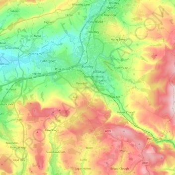
Name: Burnley topographic map, elevation, terrain.
Location: Burnley, Lancashire, England, United Kingdom (53.72300 -2.34231 53.82526 -2.11228)
Average elevation: 247 m
Minimum elevation: 63 m
Maximum elevation: 479 m
The town lies in a natural three-forked valley at the confluence of the River Brun and the River Calder, surrounded by open fields, with wild moorland at higher altitudes. To the west of Burnley lie the towns of Padiham, Accrington and Blackburn, with Nelson and Colne to the north. The centre of the town stands at approximately 387 feet (118 m) above sea level and 30 miles (48 km) east of the Irish Sea coast.
Other topographic maps
Click on a map to view its topography, its elevation and its terrain.
Cockerham
United Kingdom > England > Lancashire > Lancaster
Cockerham, Lancaster, Lancashire, England, United Kingdom
Average elevation: 8 m
Trawden
United Kingdom > England > Lancashire > Borough of Pendle
Trawden, Borough of Pendle, Lancashire, England, BB8 8SB, United Kingdom
Average elevation: 243 m
Leyland
United Kingdom > England > Lancashire > South Ribble
Leyland, South Ribble, Lancashire, England, PR25 2EX, United Kingdom
Average elevation: 41 m
Garstang
United Kingdom > England > Lancashire > Borough of Wyre
Garstang, Borough of Wyre, Lancashire, England, United Kingdom
Average elevation: 24 m
Chorley
United Kingdom > England > Lancashire
Chorley, Lancashire, England, United Kingdom, River Darwen
Average elevation: 123 m
Euxton
United Kingdom > England > Lancashire > Chorley
Euxton, Chorley, Lancashire, England, United Kingdom
Average elevation: 50 m
South Ribble
United Kingdom > England > Lancashire
South Ribble, Lancashire, England, United Kingdom
Average elevation: 40 m
Brinscall
United Kingdom > England > Lancashire > Chorley
Brinscall, Chorley, Lancashire, England, PR6 8QS, United Kingdom
Average elevation: 195 m
Lytham St Annes
United Kingdom > England > Lancashire > Borough of Fylde
Lytham St Annes, Borough of Fylde, Lancashire, England, FY8 4AR, United Kingdom
Average elevation: 5 m
Inskip
United Kingdom > England > Lancashire > Borough of Wyre
Inskip, Borough of Wyre, Lancashire, England, PR4 0SL, United Kingdom
Average elevation: 14 m
Chorley
United Kingdom > England > Lancashire
Chorley, Lancashire, England, United Kingdom
Average elevation: 113 m
Thorn Hill
United Kingdom > England > Lancashire > Lancaster
Thorn Hill, Lancaster, Lancashire, England, LA2 9BN, United Kingdom
Average elevation: 269 m
Forton
United Kingdom > England > Lancashire > Borough of Wyre
Forton, Borough of Wyre, Lancashire, England, PR3 0BG, United Kingdom
Average elevation: 30 m
Colne
United Kingdom > England > Lancashire > Borough of Pendle
Colne, Borough of Pendle, Lancashire, England, United Kingdom
Average elevation: 197 m
Farington Moss
United Kingdom > England > Lancashire > South Ribble > Farington Moss
Farington Moss, South Ribble, Lancashire, England, PR26 6RD, United Kingdom
Average elevation: 36 m
Galgate
United Kingdom > England > Lancashire > Lancaster > Galgate
Galgate, Lancaster, Lancashire, England, LA2 0RP, United Kingdom
Average elevation: 43 m
Burnley
United Kingdom > England > Lancashire > Burnley > Burnley
Burnley, Lancashire, North West England, England, BB11 1BB, United Kingdom
Average elevation: 194 m
Newburgh
United Kingdom > England > Lancashire > West Lancashire > Newburgh
Newburgh, West Lancashire, Lancashire, North West England, England, United Kingdom
Average elevation: 37 m
Billington and Langho
United Kingdom > England > Lancashire > Ribble Valley > Langho
Billington and Langho, Langho, Ribble Valley, Lancashire, England, United Kingdom, Jamacia Wood
Average elevation: 100 m
Kirkham
United Kingdom > England > Lancashire
Kirkham, Fylde, Lancashire, North West England, England, United Kingdom
Average elevation: 22 m
Manchester
United Kingdom > England > Lancashire > Manchester
Manchester, Lancashire, North West England, England, M60 2TU, United Kingdom
Average elevation: 118 m
Adlington
United Kingdom > England > Lancashire > Chorley
Adlington, Chorley, Lancashire, North West England, England, United Kingdom
Average elevation: 95 m
West Lancashire
United Kingdom > England > Lancashire
West Lancashire, Lancashire, England, United Kingdom
Average elevation: 30 m
Heysham
United Kingdom > England > Lancashire > Lancaster
Heysham, Lancaster, Lancashire, England, LA3 2DS, United Kingdom
Average elevation: 4 m
Whalley
United Kingdom > England > Lancashire > Ribble Valley
Whalley, Ribble Valley, Lancashire, England, United Kingdom
Average elevation: 95 m
Preston
United Kingdom > England > Lancashire
Preston, Lancashire, England, United Kingdom
Average elevation: 58 m
Borough of Wyre
United Kingdom > England > Lancashire
Borough of Wyre, Lancashire, England, United Kingdom
Average elevation: 58 m
Ribble Valley
United Kingdom > England > Lancashire
Ribble Valley, Lancashire, England, United Kingdom
Average elevation: 200 m
Lancaster
United Kingdom > England > Lancashire
Lancaster, Lancashire, England, United Kingdom
Average elevation: 84 m
Rawtenstall
United Kingdom > England > Lancashire > Borough of Rossendale
Rawtenstall, Borough of Rossendale, Lancashire, England, BB4 6QS, United Kingdom
Average elevation: 284 m