
Cieza topographic map
Interactive map
Click on the map to display elevation.
About this map
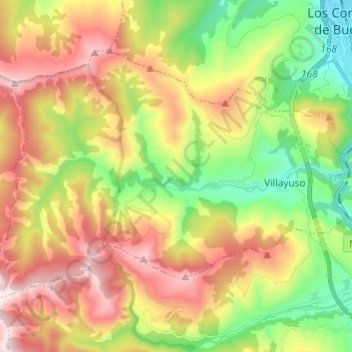
Name: Cieza topographic map, elevation, terrain.
Location: Cieza, Besaya, Cantabria, 39407, España (43.19151 -4.18685 43.25452 -4.06575)
Average elevation: 469 m
Minimum elevation: 81 m
Maximum elevation: 941 m
Other topographic maps
Click on a map to view its topography, its elevation and its terrain.
Barrio El Milagro
España > Cantabria > Besaya > Torrelavega > Torres
Barrio El Milagro, Torres, Torrelavega, Besaya, Cantabria, 39300, España
Average elevation: 52 m
Torrelavega
España > Cantabria > Besaya > Torrelavega
Torrelavega, Besaya, Cantabria, 39300, España
Average elevation: 40 m
Bostronizo
España > Cantabria > Besaya > Arenas de Iguña
Bostronizo, Arenas de Iguña, Besaya, Cantabria, 39451, España
Average elevation: 339 m
San Juan de Raicedo
España > Cantabria > Besaya > Arenas de Iguña
San Juan de Raicedo, Arenas de Iguña, Besaya, Cantabria, 39451, España
Average elevation: 314 m