
Thank you for supporting this site ❤️
Make a donation
Make a donation
Natete topographic map
Click on the map to display elevation.
Thank you for supporting this site ❤️
Make a donation
Make a donation
About this map
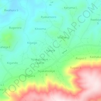
Name: Natete topographic map, elevation, terrain.
Location: Natete, Ibanda, Western Region, Uganda (-0.11698 30.44704 -0.07698 30.48704)
Average elevation: 1,500 m
Minimum elevation: 1,330 m
Maximum elevation: 1,846 m
Thank you for supporting this site ❤️
Make a donation
Make a donation