
Waihi Beach topographic map
Interactive map
Click on the map to display elevation.
About this map
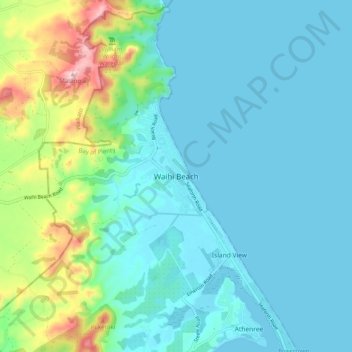
Name: Waihi Beach topographic map, elevation, terrain.
Average elevation: 58 m
Minimum elevation: 0 m
Maximum elevation: 309 m
Western Bay of Plenty District trails, hiking, mountain biking, running and outdoor activities
Other topographic maps
Click on a map to view its topography, its elevation and its terrain.
Papamoa Hills Regional Park
New Zealand > Bay of Plenty > Western Bay of Plenty District
Average elevation: 58 m