
Thank you for supporting this site ❤️
Make a donation
Make a donation
Old Bald topographic map
Click on the map to display elevation.
Thank you for supporting this site ❤️
Make a donation
Make a donation
About this map
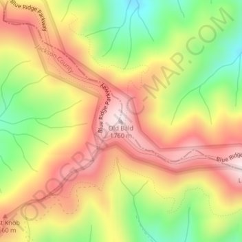
Name: Old Bald topographic map, elevation, terrain.
Location: Old Bald, Haywood County, North Carolina, United States (35.38311 -83.02769 35.38321 -83.02759)
Average elevation: 1,544 m
Minimum elevation: 1,293 m
Maximum elevation: 1,758 m
Thank you for supporting this site ❤️
Make a donation
Make a donation
Other topographic maps
Click on a map to view its topography, its elevation and its terrain.
Town of Maggie Valley
United States > North Carolina > Haywood County > Town of Maggie Valley
Average elevation: 907 m
Thank you for supporting this site ❤️
Make a donation
Make a donation