Fort Rock topographic map
Interactive map
Click on the map to display elevation.
About this map
![Fort Rock topographic map, elevation, terrain](/pub/maps/way/zkl/pjfbclmt/thumbnail.jpg)
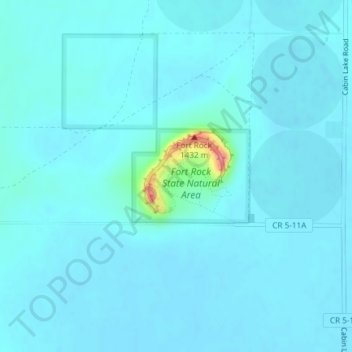
Name: Fort Rock topographic map, elevation, terrain.
Location: Fort Rock, Lake County, Oregon, United States (43.37156 -121.07473 43.37724 -121.06666)
Average elevation: 1,326 m
Minimum elevation: 1,318 m
Maximum elevation: 1,406 m
Other topographic maps
Click on a map to view its topography, its elevation and its terrain.
![Foster Lake topographic map, elevation, terrain](/pub/maps/way/fz4s/42xfzl1h/icon.jpg)
Foster Lake
United States > Oregon > Lake County
Foster Lake, Lake County, Oregon, United States
Average elevation: 1,816 m
![Christmas Valley topographic map, elevation, terrain](/pub/maps/node/9x14/jc24g5k/icon.jpg)
Christmas Valley
United States > Oregon > Lake County
Christmas Valley, Lake County, Oregon, 97641, United States
Average elevation: 1,316 m
![Adel topographic map, elevation, terrain](/pub/maps/node/bz3l/w5j4qtf/icon.jpg)
Adel
United States > Oregon > Lake County
Adel, Lake County, Oregon, 97620, United States
Average elevation: 1,467 m
![Green Creek topographic map, elevation, terrain](/pub/maps/way/j7tf/79xljkl/icon.jpg)
Green Creek
United States > Oregon > Lake County
Green Creek, Lake County, Oregon, United States
Average elevation: 1,657 m
![Lakeview topographic map, elevation, terrain](/pub/maps/relation/nf51/qzpk5k/icon.jpg)
Lakeview
United States > Oregon > Lake County
Lakeview, Lake County, Oregon, 97630, United States
Average elevation: 1,562 m