
Thank you for supporting this site ❤️
Make a donation
Make a donation
Pawtucket topographic map
Click on the map to display elevation.
Thank you for supporting this site ❤️
Make a donation
Make a donation
About this map
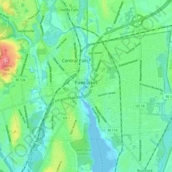
Name: Pawtucket topographic map, elevation, terrain.
Location: Pawtucket, Providence County, Rhode Island, United States (41.85665 -71.42213 41.89859 -71.33404)
Average elevation: 24 m
Minimum elevation: -8 m
Maximum elevation: 92 m
Thank you for supporting this site ❤️
Make a donation
Make a donation