
Thank you for supporting this site ❤️
Make a donation
Make a donation
New Corella topographic map
Click on the map to display elevation.
Thank you for supporting this site ❤️
Make a donation
Make a donation
About this map
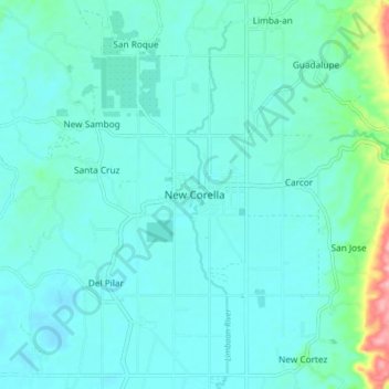
Name: New Corella topographic map, elevation, terrain.
Location: New Corella, Davao del Norte, Davao Region, Philippines (7.54604 125.78257 7.62604 125.86257)
Average elevation: 32 m
Minimum elevation: 10 m
Maximum elevation: 164 m
Thank you for supporting this site ❤️
Make a donation
Make a donation
Other topographic maps
Click on a map to view its topography, its elevation and its terrain.
Faith Tabernacle Church Sto. Tomas
Philippines > Davao del Norte > Santo Tomas
Average elevation: 36 m
Thank you for supporting this site ❤️
Make a donation
Make a donation