Geolocate

Village of Croton-on-Hudson topographic map

Interactive map

Click on the map to display elevation.

About this map

Name: 
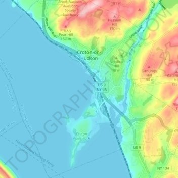
Village of Croton-on-Hudson topographic map, elevation, terrain.

Location: Village of Croton-on-Hudson, Town of Cortlandt, Westchester County, New York, 10520, United States (41.16492 -73.93732 41.22826 -73.86300)

Average elevation: 42 m

Minimum elevation: -1 m

Maximum elevation: 182 m

Other topographic maps

Click on a map to view its topography, its elevation and its terrain.

City of White Plains

United States > New York > Westchester County

City of White Plains, Westchester County, New York, United States

Average elevation: 83 m

Vista

United States > New York > Westchester County

Vista, Town of Lewisboro, Westchester County, New York, United States

Average elevation: 149 m

Quaker Ridge

United States > New York > Westchester County > City of New Rochelle

Quaker Ridge, City of New Rochelle, Westchester County, New York, 10804, United States

Average elevation: 65 m

Waverly

United States > New York > Westchester County > Town of Eastchester

Waverly, Town of Eastchester, Westchester County, New York, 10709, United States

Average elevation: 57 m

Yonkers

United States > New York > Westchester County > Yonkers

Yonkers, Westchester County, New York, United States

Average elevation: 58 m