
Thank you for supporting this site ❤️
Make a donation
Make a donation
Whatawhata topographic map
Click on the map to display elevation.
Thank you for supporting this site ❤️
Make a donation
Make a donation
About this map
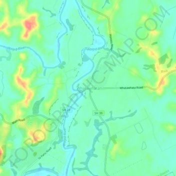
Name: Whatawhata topographic map, elevation, terrain.
Location: Whatawhata, Waikato District, Waikato, 3289, New Zealand (-37.81763 175.13335 -37.77763 175.17335)
Average elevation: 32 m
Minimum elevation: 12 m
Maximum elevation: 80 m
Waikato District trails, hiking, mountain biking, running and outdoor activities
Thank you for supporting this site ❤️
Make a donation
Make a donation
Other topographic maps
Click on a map to view its topography, its elevation and its terrain.