
Make a donation
Khammam topographic map
Click on the map to display elevation.
Make a donation
Khammam
Khammam is located at 17°15′N 80°09′E / 17.25°N 80.15°E / 17.25; 80.15. It has an average elevation of 108 metres (390 feet).
Make a donation
About this map
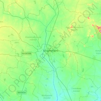
Name: Khammam topographic map, elevation, terrain.
Average elevation: 130 m
Minimum elevation: 73 m
Maximum elevation: 316 m
Make a donation
Other topographic maps
Click on a map to view its topography, its elevation and its terrain.
Greater Hyderabad Municipal Corporation East Zone
India > Telangana > Uppal mandal > Hyderabad
Average elevation: 515 m
Hyderabad
India > Telangana > Bahadurpura mandal
Hyderabad (/ˈhaɪdərəbæd/ HY-dər-ə-bad; ISO: Haidarābād, Telugu: [ˈɦaɪ̯daɾaːbaːd] , Urdu: [ˈɦɛːdəɾaːbaːd]) is the capital and largest city of the Indian state of Telangana. It occupies 650 km2 (250 sq mi) on the Deccan Plateau along the banks of the Musi River, in the northern part of…
Average elevation: 549 m