
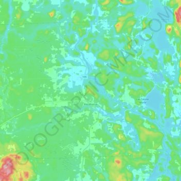
Kazabazua topographic map
Interactive map
Click on the map to display elevation.
About this map
Name: Kazabazua topographic map, elevation, terrain.
Average elevation: 178 m
Minimum elevation: 138 m
Maximum elevation: 359 m
Other topographic maps
Click on a map to view its topography, its elevation and its terrain.
Lac du Bras Coupé
Canada > Québec > La Vallée-de-la-Gatineau > Lac-Pythonga
Lac du Bras Coupé, Lac-Pythonga, La Vallée-de-la-Gatineau, Outaouais, Québec, Canada
Average elevation: 283 m
Lac d'une Rive à l'Autre
Canada > Québec > La Vallée-de-la-Gatineau > Lac-Lenôtre
Lac d'une Rive à l'Autre, Lac-Lenôtre, La Vallée-de-la-Gatineau, Outaouais, Québec, Canada
Average elevation: 394 m
Bois-Franc
Canada > Québec > La Vallée-de-la-Gatineau
Bois-Franc, La Vallée-de-la-Gatineau, Outaouais, Québec, Canada
Average elevation: 205 m
Lac Cellier
Canada > Québec > La Vallée-de-la-Gatineau > Lac-Pythonga
Lac Cellier, Lac-Pythonga, La Vallée-de-la-Gatineau, Outaouais, Québec, Canada
Average elevation: 375 m
Kitigan Zibi Anishinabeg
Canada > Québec > La Vallée-de-la-Gatineau > Montcerf-Lytton
Kitigan Zibi Anishinabeg, Montcerf-Lytton, La Vallée-de-la-Gatineau, Outaouais, Québec, J9E 2V4, Canada
Average elevation: 225 m
Rivière du Coucou
Canada > Québec > La Vallée-de-la-Gatineau > Lac-Moselle
Rivière du Coucou, Lac-Moselle, La Vallée-de-la-Gatineau, Outaouais, Québec, Canada
Average elevation: 396 m
Lac Grey
Canada > Québec > La Vallée-de-la-Gatineau > Lac-Pythonga
Lac Grey, Lac-Pythonga, La Vallée-de-la-Gatineau, Outaouais, Québec, Canada
Average elevation: 387 m
Lac du Castor Blanc
Canada > Québec > La Vallée-de-la-Gatineau > Aumond
Lac du Castor Blanc, Aumond, La Vallée-de-la-Gatineau, Outaouais, Québec, Canada
Average elevation: 251 m
Lac du Camp
Canada > Québec > La Vallée-de-la-Gatineau > Aumond
Lac du Camp, Aumond, La Vallée-de-la-Gatineau, Outaouais, Québec, Canada
Average elevation: 284 m
Lac Bow
Canada > Québec > La Vallée-de-la-Gatineau > Lac-Pythonga
Lac Bow, Lac-Pythonga, La Vallée-de-la-Gatineau, Outaouais, Québec, Canada
Average elevation: 389 m
Lac Tarse
Canada > Québec > La Vallée-de-la-Gatineau > Lac-Pythonga
Lac Tarse, Lac-Pythonga, La Vallée-de-la-Gatineau, Outaouais, Québec, Canada
Average elevation: 279 m
Lac-Sainte-Marie
Canada > Québec > La Vallée-de-la-Gatineau
Lac-Sainte-Marie, La Vallée-de-la-Gatineau, Outaouais, Québec, J0X 1Z0, Canada
Average elevation: 206 m
Déléage
Canada > Québec > La Vallée-de-la-Gatineau > Déléage
Déléage, La Vallée-de-la-Gatineau, Outaouais, Québec, J9E 2V9, Canada
Average elevation: 195 m
Lac Chalain
Canada > Québec > La Vallée-de-la-Gatineau > Lac-Pythonga
Lac Chalain, Lac-Pythonga, La Vallée-de-la-Gatineau, Outaouais, Québec, Canada
Average elevation: 384 m