
Wieluń County topographic map
Interactive map
Click on the map to display elevation.
About this map
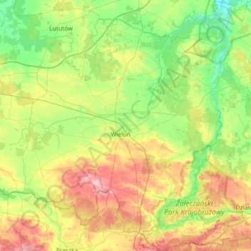
Name: Wieluń County topographic map, elevation, terrain.
Location: Wieluń County, Łódź Voivodeship, Poland (51.05448 18.34749 51.41084 18.91316)
Average elevation: 186 m
Minimum elevation: 144 m
Maximum elevation: 264 m
Other topographic maps
Click on a map to view its topography, its elevation and its terrain.
Emilia
Poland > Łódź Voivodeship > Emilia
Emilia, gmina Zgierz, powiat zgierski, Łódź Voivodeship, 95-100, Poland
Average elevation: 155 m
Wieluń
Poland > Łódź Voivodeship > Wieluń
Wieluń, gmina Wieluń, powiat wieluński, Łódź Voivodeship, Poland
Average elevation: 184 m