
Make a donation
Sun Valley topographic map
Click on the map to display elevation.
Make a donation
Sun Valley
Sun Valley is a resort city in Blaine County, Idaho, United States. The resort is adjacent to the city of Ketchum and within the greater Wood River valley. The population was 1,406 at the 2010 census, down from 1,427 in 2000. The elevation of Sun Valley (at the Lodge) is 5,920 feet (1,805 m) above sea level. Scheduled passenger airline service is available via the Friedman Memorial Airport located in nearby Hailey, approximately 15 miles (25 km) south. Visitors to Sun Valley are relatively close to the Sawtooth National Recreation Area, accessed over Galena Summit on State Highway 75, the Sawtooth Scenic Byway.
Make a donation
About this map
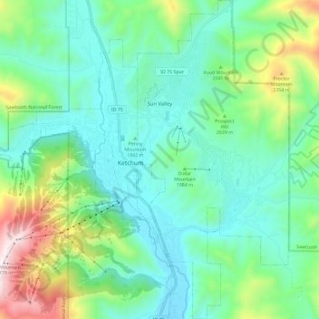
Name: Sun Valley topographic map, elevation, terrain.
Location: Sun Valley, Blaine County, Idaho, United States (43.63996 -114.36125 43.72314 -114.30661)
Average elevation: 1,988 m
Minimum elevation: 1,724 m
Maximum elevation: 2,780 m
Make a donation