
Thank you for supporting this site ❤️
Make a donation
Make a donation
Ban Luang topographic map
Click on the map to display elevation.
Thank you for supporting this site ❤️
Make a donation
Make a donation
About this map
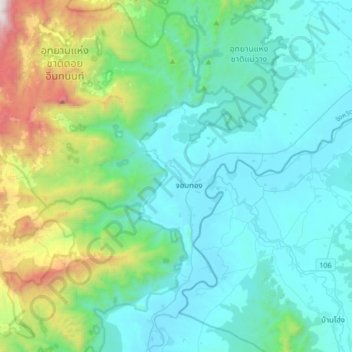
Name: Ban Luang topographic map, elevation, terrain.
Location: Ban Luang, Chiang Mai Province, Thailand (18.27031 98.50496 18.59031 98.82496)
Average elevation: 631 m
Minimum elevation: 264 m
Maximum elevation: 2,318 m
Thank you for supporting this site ❤️
Make a donation
Make a donation
Other topographic maps
Click on a map to view its topography, its elevation and its terrain.