
Ζάκυνθος topographic map
Interactive map
Click on the map to display elevation.
About this map
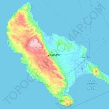
Name: Ζάκυνθος topographic map, elevation, terrain.
Average elevation: 82 m
Minimum elevation: -3 m
Maximum elevation: 749 m
Other topographic maps
Click on a map to view its topography, its elevation and its terrain.
Agalas
Griechenland > Peloponnes, Westgriechenland und Ionische Inseln > Regionalbezirk Zakynthos > Agalas
Agalas, Δήμος Ζακύνθου, Regionalbezirk Zakynthos, Region der Ionischen Inseln, Peloponnes, Westgriechenland und Ionische Inseln, 290 92, Griechenland
Average elevation: 266 m