
Make a donation
Old Toronto topographic map
Click on the map to display elevation.
Make a donation
Old Toronto
Despite its deep ravines, Toronto is not remarkably hilly, but its elevation does increase steadily away from the lake. Elevation differences range from 76.5 metres (251 ft) above sea level at the Lake Ontario shore to 209 m (686 ft) above sea level near the York University grounds in the city's north end at the intersection of Keele Street and Steeles Avenue. There are occasional hilly areas; in particular, midtown Toronto has a number of sharply sloping hills. Lake Ontario remains occasionally visible from the peaks of these ridges as far north as Eglinton Avenue, 7 to 8 kilometres (4.3 to 5.0 mi) inland.
Make a donation
About this map
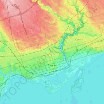
Name: Old Toronto topographic map, elevation, terrain.
Location: Old Toronto, Toronto, Golden Horseshoe, Ontario, Canada (43.61038 -79.49282 43.73602 -79.27851)
Average elevation: 116 m
Minimum elevation: 68 m
Maximum elevation: 201 m
Make a donation
Other topographic maps
Click on a map to view its topography, its elevation and its terrain.
Make a donation
Make a donation
Make a donation
Make a donation
Millbrook
Canada > Ontario > Peterborough County > Cavan-Monaghan
Peterborough's topography is largely defined by land formations created by the receding Wisconsian glaciers 10,000–15,000 years ago. The South End and Downtown portions of the city sit on what was the bottom of the glacial Lake Peterborough—part of a glacial spillway created when glacial meltwaters from…
Average elevation: 250 m
Make a donation
MacTier
Canada > Ontario > Muskoka District > Georgian Bay Township > MacTier
Average elevation: 241 m
Make a donation