
Thank you for supporting this site ❤️
Make a donation
Make a donation
Les Enceints topographic map
Click on the map to display elevation.
Thank you for supporting this site ❤️
Make a donation
Make a donation
About this map
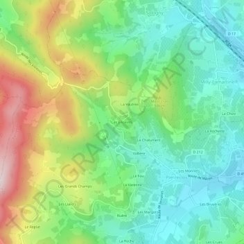
Name: Les Enceints topographic map, elevation, terrain.
Average elevation: 408 m
Minimum elevation: 241 m
Maximum elevation: 731 m
Thank you for supporting this site ❤️
Make a donation
Make a donation
Other topographic maps
Click on a map to view its topography, its elevation and its terrain.
Château de Pierreclos
France > Bourgogne-Franche-Comté > Saône-et-Loire > Pierreclos
Average elevation: 335 m